On the internet there tend to be only a few good sources on the history of streetcar and interurban service in Santa Clara County. There are some good photos, a few maps, and a book "Tracks, Tires, and Wires" by Charles McCaleb. The book can be found at several libraries in the county library system. However, from the view of intimacy with the past, this is sometimes unsatisfying. There are few articles that people can easily reference, and while the old system gets brought up in dicussions from time to time, the actual knowledge of what the system was like and how it functioned is rather poorly communicated.
One of the main reasons for this is that electric service in Santa Clara County dissapeared a generation earlier than in larger cities like Oakland, as well as some local reasons. The combination looks something like the following:
- Far less footage and pictures were recorded of the system because the necessary equipment was much less accessible in depression-era 1930s America than in the 1950s or 60s.
- The smaller size of the population of the county in the 1930s means that there is simply less historical documentation to go off of, and fewer people who remembered the system and had collections. It was also less well known.
- The huge population growth of the county in the ensuing decades completely erased much of the evidence that the system ever existed, and obfuscated a good understanding of the system.
These kinds of reasons probably make it a challenge to understand the old systems in many cities in the United States. Thankfully, in the case of Santa Clara County, there are already the sources I brought up above. The book by Charles McCaleb is excellent. Every once in a while,
someone writes a well sourced article about the topic. However, there is one untapped source that can bring more intimacy to the past, that being aerial photography. Much of the old system was captured by photos taken from planes in 1930/1931. The interurban system was gone by 1934, and the streetcars by 1938. The second round of aerial surveys was in 1939. What this means is that there is exactly
one time that the old system was captured in such a comprehensive manner.
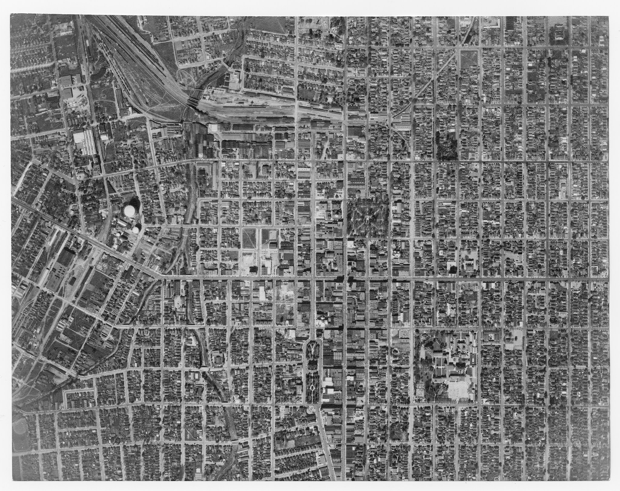
^Before you dismiss what quality photography from the 1930s looked like, here is frame 43 of Downtown San José (high res version
here) taken by
Fairchild Camera and Instrument (which, incidentally, was the precursor to Fairchild Semiconductors and the entire reason Silicon Valley grew so fast in population).
Notice the white lines running down the centers of Park street and Bird Avenue. At Market and Bassett, multiple interurbans can be seen queuing up next to the Southern Pacific Market street depot. Several stops can be seen along first street, market street, and santa clara street looking like white streaks at each intersection. Streetcars are visible in a few places. This frame is also downloadable from
Frame Finder. Search "San Jose", sort the images by date, and find this picture as a .tif file (more on this later).
There are some difficulties in bringing these historical photos to life in a proper way. The .tif format is a lossless image format, but this means that files are unreasonably large, too large to be able to display them all at once in Google Earth without lag. The images are taken from slightly different angles, meaning that the scales of the images are off and can't be lined up perfectly. There is a cost to this, and also a cost to getting all the pictures scanned and solving some potential copyright issues. One group of people I know that has the skills to correct the sizing of the images, etc, is
historic aerials. In the meantime, though, using the available images on frame finder, I made a stripped-down version
downloadable as a google earth file with routes accurate to the 1930 timeline of the images. The last Palo alto routes
had just been discontinued in 1929, and if someone wants to go back through the sources and make multiple maps to show the evolution of the system, this would be interesting as well (we have 70 years of tram history 1868-1938!). Hopefully bringing light to the existence of these photos can inspire someone with a better skillset than me to assemble them all together in a way that can help document the old electric systems in a way that the region deserves.
Commentaires
Publier un commentaire